Abstract: Introduced the use of GPS OEM board to measure and monitor the position of the navigation light, and carried out effective numerical analysis and processing of the measurement data according to the GPS OEM board error source. At the same time, the corresponding control was taken according to the characteristics of the CPS OEM board measurement reading. The strategy has achieved good practical application results and laid the foundation for the digitalization and automation construction of the waterway.
With the development of electronic technology and communication technology, wireless communication and telemetry and remote control systems are widely used in various fields such as industry, agriculture, aviation, and navigation. The estuary and inland rivers are an important part of maritime navigation, and their management and maintenance methods and quality are of great importance to China's shipping industry. Since its development, the reliability of electronic communication products is getting higher and lower, and the cost is getting lower and lower, which makes it possible to realize the automation and digitalization of waterway management and maintenance. GPS (Global Positioning System) is a satellite global navigation and positioning system developed by the U.S. Department of Defense in 1973, mainly serving its navy, land and air forces. In recent years, it has been gradually applied to civilian facilities and surveying and mapping technology. At the same time, the US military has gradually relaxed the restrictions on civilian GPS equipment, so that civilian GPS has reached a relatively high positioning accuracy. It is an ideal method to use GPS to remotely measure and monitor the navigation channel and other equipment. Based on the specific requirements of navigation mark monitoring, this article forms a GPS telemetry network with the targets to be monitored in the entire channel management area, and uses various filtering methods to eliminate the corresponding errors and improve the accuracy of telemetry data. 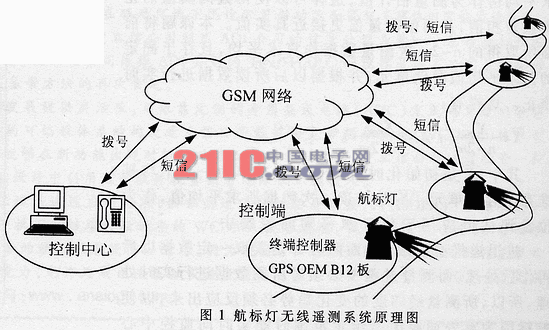
1 GPS OEM board and waterway GPS telemetry network
1.1 GPS OEM board
The GPS OEM board is an important part of the GPS receiver. It has many advantages such as low cost, small size, light weight, many product types, and high cost performance. Therefore, it is widely used in the field of positioning and navigation. Its positioning accuracy can already reach tens of meters, and can even reach an accuracy within 10 meters. The GPS OEM B12 of Thales Group Navigation and Positioning Company used in this topic is a very cost-effective product.
1.2 Channel monitoring
The waterway is an important part of the transportation network, and its safety quality directly affects the entire transportation system. In the past, the waterway department specially installed various beacon lights as warning and navigation devices near the embankment, bridge head, and faults of the waterway. Various ships can determine their own course according to the beacon lights and their flashing frequency. As for the maintenance of the beacon, it is the channel department that sends cruise ships to visually and actually measure the beacon lights at regular intervals. Because there are many beacon lights in the channel, this makes the maintenance mode of the cruise channel cumbersome, high in operation and maintenance cost, and low in safety and quality.
1.3 Channel GPS telemetry network
The navigation mark telemetry network in the waterway is mainly for telemetering the water mark (the navigation mark anchored in the water) in order to monitor its position in real time (the system schematic diagram is shown in Figure 1); 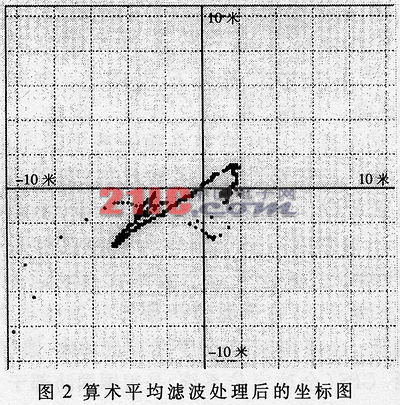 The shore mark (a navigation mark fixed on the embankment) does not require GPS telemetry because its position remains unchanged. The actual task of GPS in the navigation mark telemetry network is to measure the position of the navigation light in real time and compare it with the pre-defined position range. If it drifts out of the calibrated range, it will send an alarm message to the monitoring center through the GSM network to facilitate monitoring The center takes corresponding measures. This will eliminate the accidents caused by the drifting of the navigation light due to the collision of the ship and the impact of the current. There are hundreds of water marks in each waterway management area, so it is necessary to consider cost investment while improving safety quality. According to the specific requirements of the channel, its accuracy does not need to be accurate below the meter level, so it does not require expensive high-precision GPS receivers and measuring instruments. At the same time, bundling the GPS OEM board with the water mark can achieve a high-quality management effect at a relatively low cost. This system uses the B12 GPS OEM board module produced by the French Thales company, which has 12 parallel receiving channels (that is, it can receive ephemeris information transmitted by 12 positioning satellites at the same time).
2 Error analysis, numerical processing and control process
2.1 Error analysis
The errors of GPS measurement mainly include errors caused by satellites, signal propagation, signal reception and other aspects, but they can be summarized as systematic errors and random errors in nature. Systematic errors mainly include satellite ephemeris errors, satellite clock errors, receiver clock errors, and atmospheric refraction errors. The random error mainly includes the multipath effect of the signal. Although the system error is larger than the random error, its elimination depends mainly on the receiver itself [1], but it always has certain rules to follow, so it is very important to take certain measures to deal with the reliability of the entire system of. Because the multipath effect on the water surface is relatively serious, the use of a precision phase center and a measuring antenna with a donut current loop is an important method to eliminate errors caused by the water surface environment.
2.2 Numerical processing
For various errors, various filtering methods have been applied in the measurement technology to eliminate or reduce the effects of various errors, such as median filtering method, arithmetic average filtering method, forward and backward recursive filtering method, etc. Through a large number of measurement tests and observation analysis, it has been found that with the time, the change of satellite distribution and the change of weather, the data read by GPS has drifts in different curve directions, but its distribution is close to normal distribution, so it is The processing of data by some filtering methods is crucial to the improvement of the accuracy of the entire measurement system. The following are several filtering methods used in the system. 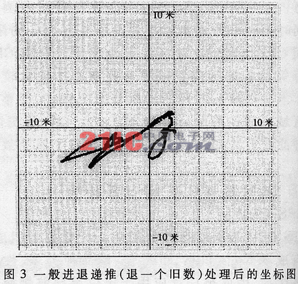
Median filtering method: Sort the three measured data, remove the largest and smallest ones, and take the median value as the measured value. Based on this idea, this paper continuously measures n (adjustable) latitude and longitude data when the terminal controller is powered on and initializes it and queues them from small to large, removing the largest m-th data and the smallest m-th data. The n-2m times data is used as a reference and stored in a storage unit. Since the channel telemetry system does not have high real-time requirements, n should be made as large as possible. If the sum of the data read n times is Xn, the sorted sum of the smallest m times data is XmMIN, and the sum of the largest m times data is XmMAX, then:
Xsum = Xn-XmMIN-XmMAX
Store Xsum in the storage unit as the sum of the subsequent processing methods. Arithmetic average filtering method: that is, sampling a certain amount of data, and then averaging it as a measurement estimate, which can make the positive and negative errors from the true value cancel, so that the measured value is closer to the true value. In this subject, the n-2m measurement data obtained earlier is arithmetically averaged and stored in a fixed arithmetic average storage unit, and corrected in real time according to the data read later. This has:
X = (Xswn) / (n-2m); Xi = (Xsumi) / (n-2m).
Among them, X is the average value obtained during initialization, and is stored in the storage unit as an average reference. Xi is the average value obtained every time the data is read, and is used as the position evaluation value in the position drift judgment control. 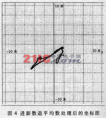
Forward and backward recursive filtering method: the first two are after reading certain data and then post-processing, and the measured data must be processed in real time during the measurement process. Therefore, the change trend of the measured latitude and longitude must be reflected, so that when the navigation mark drifts out of the given range due to an accident, it can send alarm information to the monitoring center in real time to make corrections. Based on the results of experiments and observations, this paper adopts a forward-backward recursive filtering method that advances a new number and returns an average, namely:
Xswni = Xsum_i-1 + Xi-1 + xi
Limiting filtering method: In the measurement process, it often encounters coarse errors far away from the median. This will have a greater impact on the data reference processed by the previous filtering methods, and the limiting filtering method is aimed at this idea. Set a threshold, when the measured data is compared with the reference data, if the difference exceeds the threshold, it is considered as a gross error and discarded. However, in this subject, if the beacon light drifts far away due to an accident, it must be able to be identified, and not be discarded as gross errors. Therefore, a counter is specially designed in the control program to count the round-off ratio. If the round-off ratio is greater than a certain value, it is re-initialized, that is, re-reading the sum benchmark and its arithmetic average benchmark for n-2m times.
Figure 2, Figure 3, and Figure 4 are schematic diagrams of the coordinates after performing several kinds of data processing on the 10-hour GPS data collected by the data collection and processing program developed by Visual Basic 6.0 (where the horizontal axis and the vertical axis represent the latitude). As can be seen from these three figures, from Figure 2 to Figure 4, the data convergence is enhanced in sequence. It can be seen that integrating several filtering methods in data processing will greatly reduce errors and improve system accuracy. 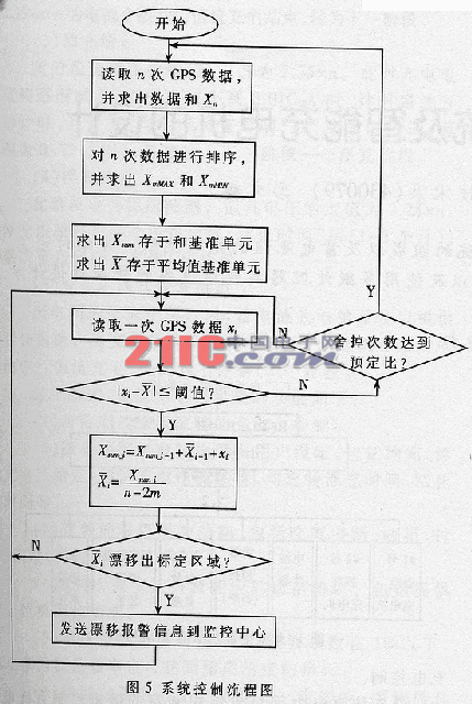
2.3 Control flow
The system control flow chart is shown in Figure 5.
In this paper, through a lot of experiments and measurement observations, the source and law of errors of the GPS OEM board are thoroughly investigated, and the corresponding numerical processing methods and control strategies are adopted, which greatly improves the application value and reliability of the GPS OEM board in the telemetry system and guarantees It is the GPS OEM board—a very meaningful application example for the accuracy and safety of the remote measurement and monitoring of the position of the beacon in the course maintenance.
Enershare's commitment to future-ready energy solutions for smart home innovations, Enershare's Energy Storage Systems create a flexible energy maintenance system for homeowners who want to take more control of their home energy use, it is intended to be used for Home Battery energy storage and stores electricity for solar self-consumption, load shifting, backup power, and off-the-grid use. you can use it anytime you want-at night or during an outage.
Residential Energy Storage System
Home Energy System,Home Battery Storage 10Kwh,Residential Energy Storage Unit,Residential Energy Storage System,Battery Energy Storage Solutions,Home Energy Storage Systems
Shenzhen Enershare Technology Co.,Ltd , https://www.enersharepower.com